TONIGHT, NICK. RAIN DELAYS. THERE’S A POSSIBILITY THAT JAMIE. BUT IF YOU HAVE TICKETS TO THE BALL GAME, IF YOU HAVE PLANS, KEEP YOUR PLANS. FOR NOW. DON’T CANCEL THEM TO MONITOR THE FORECAST THROUGHOUT THE DAY, AND WE’LL LET YOU KNOW IF WE THINK THAT MAYBE IT’S NOT THE BEST IDEA. AT THE VERY LEAST, MAKE SURE YOU HAVE THE KMBC APP ON YOUR SMARTPHONE. THAT WAY YOU’RE RECEIVING THE LATEST WEATHER INFORMATION. IF THERE ARE ANY WARNINGS OR WATCHES ISSUED LATER TODAY, YOU’LL GET THOSE IN PLENTY OF TIME TO GET TO A SAFE PLACE. WE STILL HAVE ONE ACTIVE SEVERE THUNDERSTORM WARNING NEAR NORTHERN MISSOURI IS JUST TO THE WEST OF CHILLICOTHE, AND THIS IS GOING TO LAST UNTIL 930 THIS MORNING AND INCLUDES THE COMMUNITIES OF HAMILTON, BRECKENRIDGE OVER TO UTICA AND CHILLICOTHE. THERE ON 36 HIGHWAY AND 65 HIGHWAY. POTENTIAL FOR WIND GUSTS OF 50 TO 60MPH, MAYBE NICKEL SIZE HAIL. SO WE’LL CALL THIS A MARGINAL SEVERE THUNDERSTORM, BUT IS PRODUCING A LOT OF LIGHTNING AND VERY HEAVY RAINFALL. AND THAT STORM HAS BEEN JUST STRENGTHENING AND WEAKENING, STRENGTHENING AND WEAKENING. I WOULD SAY THAT NORTHERN MISSOURI, YOU KNOW, THE ENVIRONMENT IS FAVORABLE FOR LOTS OF SEVERE THUNDERSTORMS THIS MORNING. MAYBE JUST ONE MARGINAL SEVERE THUNDERSTORM. THAT’S ALL TO THE NORTH OF KANSAS CITY. HAVE A LITTLE BATCH OF RAIN SHOWERS, SOME LIGHTNING POPPING UP THERE NEAR LEAVENWORTH. I THINK THAT’S GOING TO CONTINUE THROUGH THE MORNING, ESPECIALLY TO THE NORTH OF THE METRO. SO THERE WILL BE PLENTY OF FUEL FOR THUNDERSTORMS TODAY BETWEEN 3 AND 11:00 THIS EVENING. SCATTERED SEVERE STORMS ARE LIKELY, BUT I WANT TO EMPHASIZE THE THREAT FOR ANY LOCATION MAY ONLY LAST A FEW HOURS. IT’S NOT GOING TO STORM FROM 3 TO 11 EVERYWHERE, IN EVERY COMMUNITY. AND THE MAIN THREAT WOULD BE FOR VERY LARGE HAIL, DAMAGING WIND. I CAN’T ENTIRELY RULE OUT A TORNADO OR FLASH FLOODING. SO THAT RISK IS GREATEST HERE WITHIN THIS ORANGE SHADED AREA THAT INCLUDES KANSAS CITY. BUT I’M REALLY FAVORING COMMUNITIES NORTH OF THE METRO FOR THE GREATEST POTENTIAL OF SEVERE WEATHER. LATE THIS AFTERNOON INTO THIS EVENING. SO HERE’S THIS MORNING, SCATTERED SHOWERS AND STORMS ACROSS NORTHERN MISSOURI. THEN BEGINNING AT 3:00, INDIVIDUAL THUNDERSTORMS DEVELOPING THOSE WOULD POSE THE GREATEST RISK OF SEVERE WEATHER. AND THEN THOSE INDIVIDUAL STORMS WILL MERGE INTO CLUSTERS AND LINE SEGMENTS. THIS WOULD BE MORE OF A DAMAGING WIND AND FLASH FLOODING RISK, THOUGH EVEN AT THIS TIME AT 7:00, I CAN’T ENTIRELY RULE OUT A TORNADO. YOU NOTICE THAT’S ALL NORTH OF KANSAS CITY AT 7:00, AND THOSE STORMS ATTEMPT TO MAKE IT SOUTH TO THE METRO THROUGH 11, BUT THEY WEAKEN. NOW, THAT’S ONE TREND THAT I’VE SEEN IN SOME OF THESE THUNDERSTORM PREDICTING MODELS THIS MORNING. I’M NOT READY TO CALL THE ALL SAFE HERE FOR KANSAS CITY THIS EVENING. THAT’S A TREND THAT WE’RE GOING TO MONITOR THROUGHOUT THE MORNING IN THE AFTERNOON. THAT’S WHY WE WANT YOU TO KEEP YOUR EVENING PLANS. BUT MAKE SURE THAT YOU’RE STAYING ALERT, CHECKING THE FORECAST BEFORE YOU HEAD OUT, AND MAKING SURE YOU HAVE WAYS TO RECEIVE ALERTS LIKE THE KMBC APP, ESPECIALLY AFTER 7:00. AND DEPENDING ON HOW THIS ALL PLAYS OUT TODAY, WILL DETERMINE THE SEVERE RISK FOR THURSDAY. THE GREATEST RISK OF SEVERE WEATHER HERE O
The 11:30 a.m. update from the Storm Prediction Center increases tornado probabilities for parts of the Kansas City region. Wednesday is a First Alert Weather Alert Day. Severe thunderstorms are likely today, with a risk of very large hail, damaging winds, a couple of tornadoes, and flash flooding.A TORNADO WATCH has been issued for the following counties until 9 p.m.:Kansas: Atchison County, Doniphan County, Johnson County, Leavenworth County, Wyandotte County.Missouri: Adair County, Andrew County, Atchison County, Buchanan County, Caldwell County, Carroll County, Chariton County, Clay County, Clinton County, Daviess County, DeKalb County, Gentry County, Grundy County, Harrison County, Holt County, Jackson County, Lafayette County, Linn County, Livingston County, Macon County, Mercer County, Nodaway County, Platte County, Putnam County, Randolph County, Ray County, Saline County, Schuyler County, Sullivan County, Worth County.Time: 3 p.m. to 11 p.m. Individual severe storms will initially develop north of Kansas City across northeast Kansas and northern Missouri near Highway 36 as early as 3 to 4 p.m. These storms will have the greatest potential to produce very large hail or a tornado. This is where the tornado probability is increasing: Near the Chillicothe, Trenton, Gallatin and Bethany areas. By 7 p.m., thunderstorms will likely have grown into clusters or line segments, which would promote more of a damaging wind and flash flooding risk, though a tornado can’t entirely be ruled out. Kansas City’s risk of severe weather will begin to increase at this time and continue through 11 p.m., when storms are expected to dissipate. It’s worth mentioning that some of the high-resolution models we use to predict thunderstorms show much of the storm and severe weather activity remaining north of Kansas City this evening, though I’m not ready to sound the all-clear for the metro just yet.Very large hail and damaging winds are the primary threats, especially while storms remain individual or discrete. Once storms begin to merge into clusters or line segments, damaging winds will become more likely than very large hail.I can’t entirely rule out a tornado, especially with individual or discrete storms this afternoon and early evening. While that threat appears greatest north of Kansas City, it’s something we will monitor closely for changes through the day.Though the threat of thunderstorms for any location will only last a few hours, there is a ton of moisture hanging in the atmosphere. If storms repeatedly move over the same spots, flash flooding could occur.Please monitor the situation throughout the day and check the forecast before heading out. Have multiple ways to receive alerts like the KMBC app, a NOAA Weather Radio and Wireless Emergency Alerts (WEAs) on compatible smartphones.
The 11:30 a.m. update from the Storm Prediction Center increases tornado probabilities for parts of the Kansas City region.
Wednesday is a First Alert Weather Alert Day. Severe thunderstorms are likely today, with a risk of very large hail, damaging winds, a couple of tornadoes, and flash flooding.
A TORNADO WATCH has been issued for the following counties until 9 p.m.:
Kansas: Atchison County, Doniphan County, Johnson County, Leavenworth County, Wyandotte County.
Missouri: Adair County, Andrew County, Atchison County, Buchanan County, Caldwell County, Carroll County, Chariton County, Clay County, Clinton County, Daviess County, DeKalb County, Gentry County, Grundy County, Harrison County, Holt County, Jackson County, Lafayette County, Linn County, Livingston County, Macon County, Mercer County, Nodaway County, Platte County, Putnam County, Randolph County, Ray County, Saline County, Schuyler County, Sullivan County, Worth County.
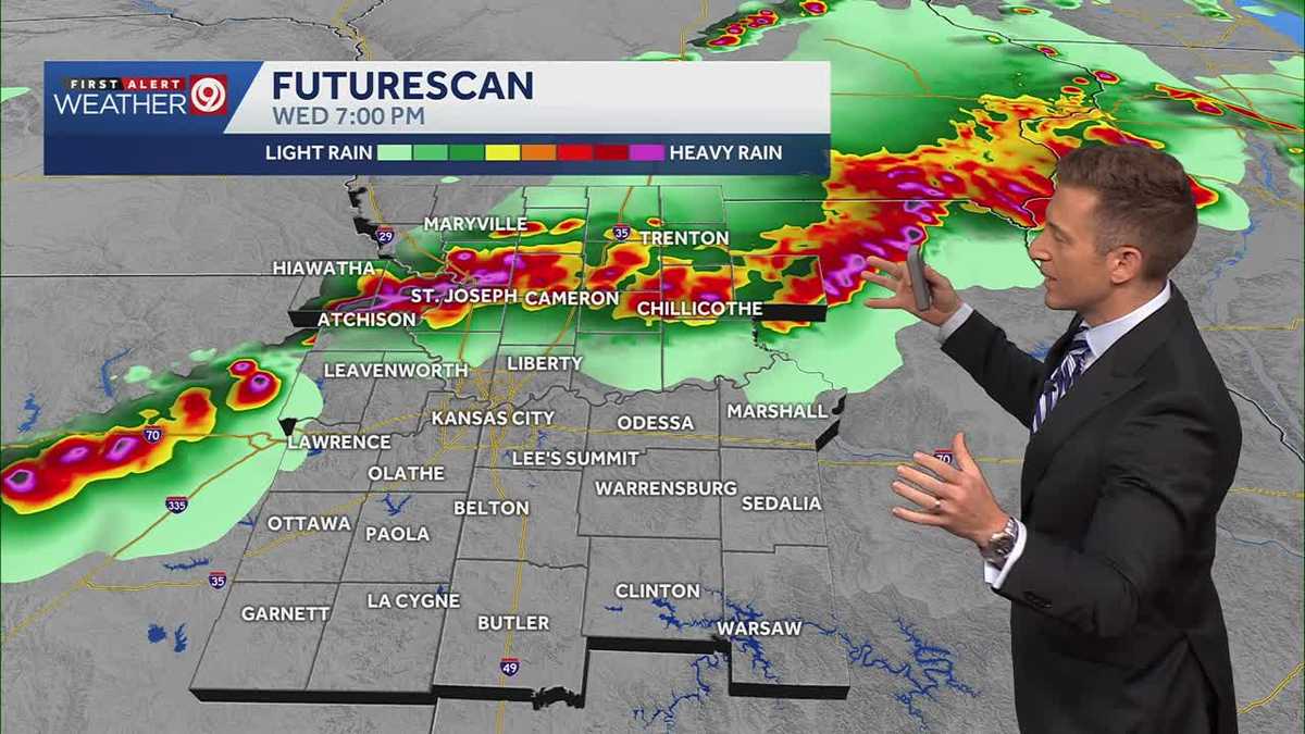
Time: 3 p.m. to 11 p.m.
Individual severe storms will initially develop north of Kansas City across northeast Kansas and northern Missouri near Highway 36 as early as 3 to 4 p.m. These storms will have the greatest potential to produce very large hail or a tornado. This is where the tornado probability is increasing: Near the Chillicothe, Trenton, Gallatin and Bethany areas.
By 7 p.m., thunderstorms will likely have grown into clusters or line segments, which would promote more of a damaging wind and flash flooding risk, though a tornado can’t entirely be ruled out. Kansas City’s risk of severe weather will begin to increase at this time and continue through 11 p.m., when storms are expected to dissipate.
It’s worth mentioning that some of the high-resolution models we use to predict thunderstorms show much of the storm and severe weather activity remaining north of Kansas City this evening, though I’m not ready to sound the all-clear for the metro just yet.
Very large hail and damaging winds are the primary threats, especially while storms remain individual or discrete. Once storms begin to merge into clusters or line segments, damaging winds will become more likely than very large hail.
I can’t entirely rule out a tornado, especially with individual or discrete storms this afternoon and early evening. While that threat appears greatest north of Kansas City, it’s something we will monitor closely for changes through the day.
Though the threat of thunderstorms for any location will only last a few hours, there is a ton of moisture hanging in the atmosphere. If storms repeatedly move over the same spots, flash flooding could occur.
Please monitor the situation throughout the day and check the forecast before heading out. Have multiple ways to receive alerts like the KMBC app, a NOAA Weather Radio and Wireless Emergency Alerts (WEAs) on compatible smartphones.
Source link